- Show how the main seasons of the climate in Cameroon are the results of the influence of air masses from different sources. Cameroon GCE June 2015
CLIMATIC TYPES AND REGIONS IN CAMEROON
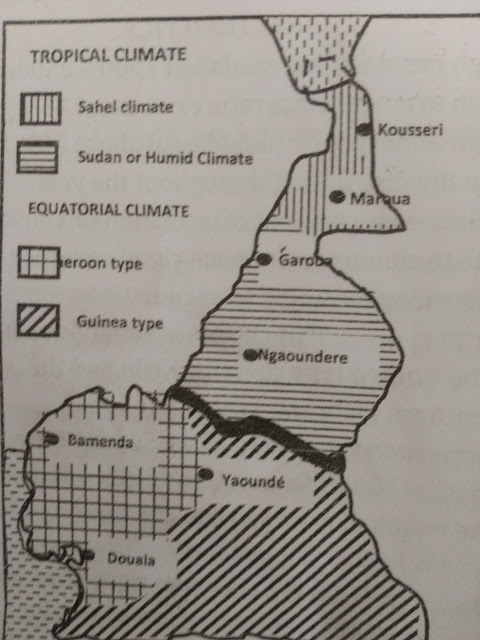
Cameroon can conveniently be divided into two climatic types: The Equatorial climate and the Tropical climate.
The Equatorial climate covers the whole southern region around latitude 2° to 6° north. This climate covers mainly the coastal low lands and southern low plateau.
Characteristics
- High mean annual rainfall of 2000-2500mm.
- High average temperatures of about 26°c
- High atmospheric humidity of about 70% fairly equally distributed through out the year.
- Relative low amount of insolation or sunshine due to cloudiness or much cloud cover absorbing incoming solar radiation. This climate is subdivided into the Guinea type covering Kribi and the Whole southern plateau.
- Cameroon type found in the south western coast of mount Cameroon and extends down to the mount of river Sanaga. The Cameroonian type is further divided into
Maritime Cameroon type. Covering the coastal lowlands where sea-facing regions experience heavy rains yearly especially the wettest place in west Africa Debunscha (10000mm) ranling second wettest place in the world after Chirapunji in India.
Mountain Cameroon type covering mainly mountains in the western highlands with fresher climates
The Tropical climate belongs to the northern region of Cameroon covering part of the Western high lands, Adamawa plateau and the northern low lands. It should be noted that there is a considerable reduction in rainfall as one progressively moves from the south to the north.
Characteristics
- Gradual reduction of rainfall from south to north example Garoua 1500m and Kousseri 630mm.
- High and fluctuating temperature rather increasing from south to north from 26°C (south) to (28°) north.
- High insulation of sunshine intensity due to penetration of sunlight.
- High evapotranspiration rate due to absence of rain, vegetation an above all droughts as seen on the map below.
The Tropical climate can also be divided into two types namely: The Sudan or Humid Tropical climate and the Sahel climate
- The Sudan or Humid Tropical climate. It extends around latitude 6° to 10° north. It covers the Adamawa plateau characterized by two seasons. A rainy season and a dry season. The rains are of great intensity due to relief factors accompanied by great storms. The rainfall generally low lasting tp 6-7 months. Temperatures are fresher 21°C 6n the average.
- The Sahel climate: this climatic domain covers the Benue basins Diamare plains, Mayo Dannay, to the shores of lake chad. Rainfall reduces further north lasting just for 3 months. The average is 300-500mm with a longer dry season of 9months. It id greatly affected by drought.

